
Huai Pong Gr
Type Locality and Naming
Mae Hong Son basin (NW Thailand), near Myanmar, north of Mae Ping Fault. Named by Meesook and Grant0Mackie (1996) after the Huai Pong village, Mueang district, Mae Hong Son province. Type section at Km 8-9 along road from Pa Lan village and Klang village to Mae Sariang-Mae Hong Son highway. Subdivisions: Consists of 3 formations in ascending order: Pa Lan Fm, Mai Hung Fm, and Kong Mu Fm.
Synonym: กลุม่หินห้วยโป่ง
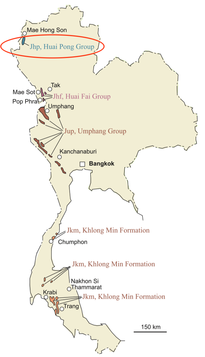
[Figure: Distribution of marine Jurassic rocks and their principal lithostratigraphic units (redrawn from Meesook & Grant-Mackie 1996, by Meesook A. & Saengsrichan W., 2011, Page 152).]
Lithology and Thickness
Mixed marine. Shale and sandstone in the lower part; limestone and siltstone in the middle part; and sandstone in the upper part. Thickness: 200 m
Relationships and Distribution
Lower contact
"The relationship between this group and older strata is uncertain because of inadequate exposure. Contacts with the Triassic marine strata are inferred both to be fault-bounded and also unconformable" (Ueno & Saengsrichan, 2011)
Upper contact
Not given
Regional extent
Mae Hong Son basin (northern part of Mae Hong Son – Kanchanaburi Basin); Northern Region: Mae Hong Son and Tak provinces. Crops out mainly in two areas: Pa Lan in Mae Hong Son Province and Huai Ta Pu Kho in Tak Province.
GeoJSON
Fossils
Ammonites, bivalves and foraminifera indicate that the group ranges in age from Toarcian to Aalenian.
Age
Depositional setting
Additional Information
"The Mae Hong Son–Kanchanaburi Basin lies in north- western and western Thailand from Mae Hong Son in the north through Mae Sot, Pop Phra and Umphang to Kanchanaburi in the south. It also extends westwards into the southern Shan and Karen states of eastern Myanmar. The marine Jurassic strata of Thailand are approximately 900 m thick in the Mae Sot – Umphang and Pop Phra areas, thinning northwards and southwards to c. 200 m or less. They consist of dark grey mudstone, lime- stone, marl, sandstone and conglomerate unconformably overlying Triassic or older strata, although a conformable contact has been reported within the Kamawkala Limestone and the overlying upper Mae Moei Group (Von Braun & Jordan 1976). The Jurassic strata are generally overlain unconformably by Quaternary strata and are well exposed in five areas: Mae Hong Son, Mae Sot, Pop Phra, Umphang and Kanchanaburi, but the lithostratigraphic nomenclature (Figs 7.1 & 7.3 in Meesook & Saengsrichan, 2011) is generally different for each area because of discontinuous exposure and the difficulty of direct litho- logic correlation. The strata, however, are regarded as the product of a single depositional basin with broadly similar lithologies, depositional environments and faunal assemblages that pass into each other by lateral facies change. Meesook & Grant-Mackie (1996) have described the marine lithostratigraphic units in the Mae Hong Son – Kanchanaburi Basin." (in Meesook & Saengsrichan, 2011)